If you love the idea of living on the water in Naples but do not need sand in your front yard, you have great options. Canal-front, bay-front, and Gulf‑access homes each offer a different mix of boating, views, and upkeep. The trick is knowing how these differences affect your day-to-day life and long-term value. In this guide, you will learn how the main waterfront types compare, what to check for boat access and permits, how insurance works, and how to shop smart in Collier County. Let’s dive in.
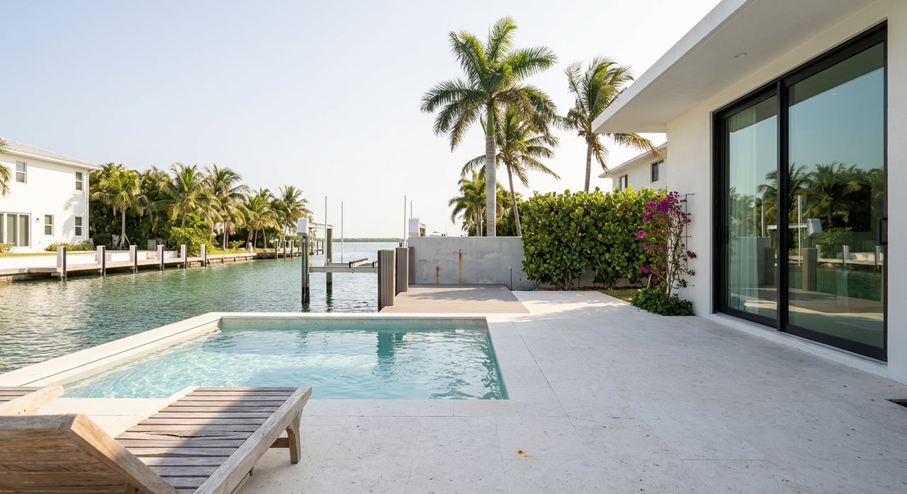
Canal-front homes sit on man-made or modified canals that lead toward Naples Bay or tidal creeks. You often get protected, low-wave mooring and the ability to keep a boat on a private dock right behind the house. Depth and width vary by canal, which can limit boat size and draft. Ask about recorded canal maintenance, recent dredging, and the seawall’s age and permit history.
Popular canal neighborhoods include Royal Harbor and Aqualane Shores. Policies on docks and lifts can differ by community or even by street, so confirm HOA rules if they apply. If you plan to run a larger boat or a towered center console, verify low-tide depths and any bridge clearance limits on your exact route.
Bay-front homes sit directly on Naples Bay or larger estuarine waters. You tend to enjoy wider water views and more direct access to marked channels, which can shorten your run time to the Gulf. With that exposure comes more current and wind than a narrow canal, and sometimes more boat traffic.
Bay-front properties can also be subject to shoreline and habitat protections. Florida’s sovereignty submerged-lands rules shape what you can build or repair waterward of the mean high-water line. Before planning a dock, check whether the site is an upland riparian shoreline versus a protected mangrove or seagrass area, and review the state’s rules for docks and preempted area limits using the Florida Administrative Code for submerged lands Chapter 18-21.
Gulf-front homes sit on the beach with direct Gulf views and usually command the highest premiums. Gulf-access homes are on canals or the bay with a navigable route to the Gulf, typically via Naples Bay and Gordon Pass. Listings that say “Gulf access” do not guarantee that your specific boat can make the trip. Check depth at mean low water, shoaling patterns, bridge clearances, and dredging history before you rely on a listing term.
In Naples, waterfront type and view often drive value as much as square footage. Direct Gulf frontage and wide-bay exposure commonly carry substantial premiums, and inventory behaves differently from inland homes. You should expect fewer comparable sales and more price dispersion across lot sizes, orientations, and dock setups. To understand current premiums and inventory patterns by corridor, review the latest monthly market statistics from the Naples Area Board of REALTORS using the NABOR market reports.
For many Naples boaters, Gordon Pass is the main gate to the Gulf. Navigability depends on channel shoaling, dredging cycles, and tide stage. The U.S. Army Corps of Engineers manages federal maintenance dredging for the Naples to Big Marco Pass corridor and publishes project notices that affect access. Reviewing the Corps’ current updates for the corridor can help you plan around maintenance windows and depth changes. See the Jacksonville District’s dredging scoping notice for the Naples to Big Marco Pass project.
Two canals can look similar but perform very differently at low tide. Older canals may have shallower controlling depths or seasonal shoaling near intersections. Confirm mean low-water depths along your route using public tide resources and local marine charts. NOAA’s Tides and Currents provides station data and chart references that help you assess draft limits and tidal swing.
A fixed bridge can turn a “yes” into a “no” for a towered sportfisher or a sailboat with a tall mast. Identify every bridge between your dock and the Gulf, and verify posted vertical clearances at mean high water. Combine local knowledge with charts, then do a test run with the seller or marina when possible.
If a private dock is not the right fit, you can consider a deeded slip or a leased marina berth. Each option has rules on slip length, lifts, fuel, pump-out, and transferability. Before you fall in love with a condo that advertises a slip, confirm whether slip rights are deeded, assigned, or waitlisted, and get the permitted vessel length and any transfer rules in writing.
Any structure waterward of the mean high-water line may require state authorization. Florida’s sovereignty submerged-lands rules govern docks, piers, and seawalls that extend into state-owned waters. Ask sellers for copies of permits or letters of consent for existing marine structures. You can view the core state standards in the Florida Administrative Code for submerged lands. Larger projects or any dredge-and-fill work may also require federal authorization from the U.S. Army Corps.
Most canal and bay lots use seawalls or bulkheads. Age, tieback condition, and any signs of scour will affect your near-term maintenance costs. Replacements or major repairs usually trigger permits and can be expensive, depending on site access and materials. In some settings, Florida DEP and Sea Grant promote living-shoreline or hybrid approaches that can reduce maintenance and add ecological value. Learn more about living-shoreline options from the Florida DEP Resilient Florida program. For cost planning ranges and common materials, contractor guides provide helpful context, but always seek engineered bids for a specific lot.
Flood risk and insurance pricing vary block by block. FEMA’s Risk Rating 2.0 sets NFIP premiums using factors like distance to water, flood types, elevation, and replacement cost. Two nearby homes can have very different quotes. Review FEMA’s overview of Risk Rating 2.0, then request both NFIP and private flood quotes early in your search.
Local flood maps and elevation certificates matter for both permitting and insurance. The City of Naples hosts updated municipal flood-zone maps. Collier County’s floodplain page explains elevation-certificate guidance and how Letters of Map Amendment can change a property’s status. Many lenders require flood insurance if a home is in a mandatory purchase zone, so verify the designation upfront.
Coastal homeowners policies are separate from flood insurance. In Florida, wind and hurricane coverage can be priced and underwritten differently from inland areas. Start your quotes and conversations early so you can compare deductibles, coverage limits, and timelines for policy binding before you go under contract.
Southwest Florida can experience seasonal harmful algal blooms, including Karenia brevis red tide, which may affect beach days, boating, or fishing at times. The Florida Fish and Wildlife Conservation Commission publishes frequent status updates and maps. Check current conditions with the FWC’s red tide updates for Collier County when planning visits or showings.
Long-term sea level trends and high-tide flooding influence elevation strategy, landscaping, and future-proofing. NOAA’s Tides and Currents provides tide gauges and sea level resources to help you plan across 10 to 30 years and beyond. Recent storms have also shown that surge can exceed older modeled scenarios. Use this context to weigh elevation, shutter systems, and community mitigation investments when you compare homes.
Use this quick list early in your search and again before you go under contract:
If you are weighing canal-front protection against bay-front views or want to confirm a clean route through Gordon Pass, you do not have to figure it out alone. I help Southwest Florida buyers compare real waterfront options, line up inspections and elevation certificates, and move with confidence using Compass tools. From on-water tours to private previews and pre-market access, you will get a clear plan for your goals. When you are ready to start your Naples waterfront search, reach out to David Burnham.
Address
800 Laurel Oak Dr., #400
Naples, FL 34108